


Bagnols les Bains

PhilippeC54
User
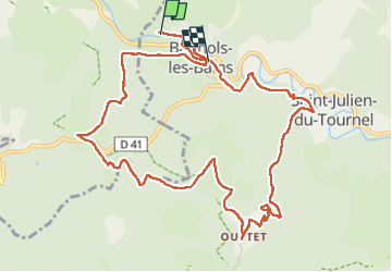

Length
12.8 km

Max alt
1169 m

Uphill gradient
407 m
Km-Effort
18.2 km

Min alt
900 m

Downhill gradient
392 m
Boucle
No
Creation date :
2024-08-09 07:33:18.814
Updated on :
2024-08-09 11:26:35.127
3h38
Difficulty : Medium

FREE GPS app for hiking
 SityTrail
IGN / Geographical institutes
SityTrail Plus
The world is yours!
About
Trail Walking of 12.8 km to be discovered at Occitania, Lozère, Mont Lozère et Goulet. This trail is proposed by PhilippeC54.
Positioning
Country:
France
Region :
Occitania
Department/Province :
Lozère
Municipality :
Mont Lozère et Goulet
Location:
Bagnols-les-Bains
Start:(Dec)
Start:(UTM)
552200 ; 4928670 (31T) N.
Comments